
Do vehicle owners in Massachusetts drive more miles on average with electric vehicles compared to non-electric vehicles? Which municipalities have added or subtracted the most vehicles since 2020? MassDOT’s Office of Transportation Planning (OTP) and the Office of Performance Management and Innovation (OPMI) developed the Massachusetts Vehicle Census (MVC) to answer those questions. The MVC is the first dataset in the country to link vehicle attributes such as garaging location and engine-type with vehicle mileage. The current MVC is modelled off a Massachusetts Vehicle Census dataset previously produced by the Metropolitan Area Planning Council (MAPC), which represented vehicles from 2009 to 2014.
The MVC datasets provide four main metric categories: Geographic, Time, Vehicle Attribute, and Driving Behavior. OPMI combines the four metric categories to create a longitudinal dataset that supports transportation planning, climate policy, and equity analyses.
A vehicle’s garaging address, essentially where a car is kept at night, establishes the geographic metric. Most passenger vehicles are garaged at the owner’s home address, while commercial vehicles are garaged either at a home address or a business’s private lot. OPMI uses the garaging address to derive the vehicle’s Municipality, Zip Code, and Block Group.
OPMI creates the time metric from historical registration data. The Massachusetts Registry of Motor Vehicles (RMV) stores historical registration data in their ATLAS database. OPMI creates snapshots by querying the database to see which vehicles are actively registered on particular dates. Researchers can easily view trends by comparing one snapshot to another.
The RMV database also contains vehicle attribute data for every registered vehicle. Some metrics, like the Model Year, Weight Class, and Fuel Class, describe the physical characteristics of the vehicle. Vehicle Use describes how the vehicle is used: is the vehicle a Passenger, Commercial, Municipal, or State vehicle?
OPMI estimates vehicle miles travelled (VMT) using vehicle inspection data. Massachusetts requires vehicle owners to get their vehicles inspected annually. During the annual vehicle inspection, its odometer reading is recorded. OPMI calculates Daily VMT as the difference between successive odometer readings divided by the total number of days between the successive odometer readings.
The MVC was developed in response to Chapter 179 of the Acts of 2022, which required that MassDOT create an anonymized and aggregated database of motor vehicle types and locations. Since the original publication in 2023, OPMI has expanded the MVC with new features and datasets. Dataset update frequency has increased from semiannually to quarterly and more vehicle attributes have been added. User feedback has prompted OPMI to add more metrics to the published datasets, such as the vehicle’s age and weight classification.
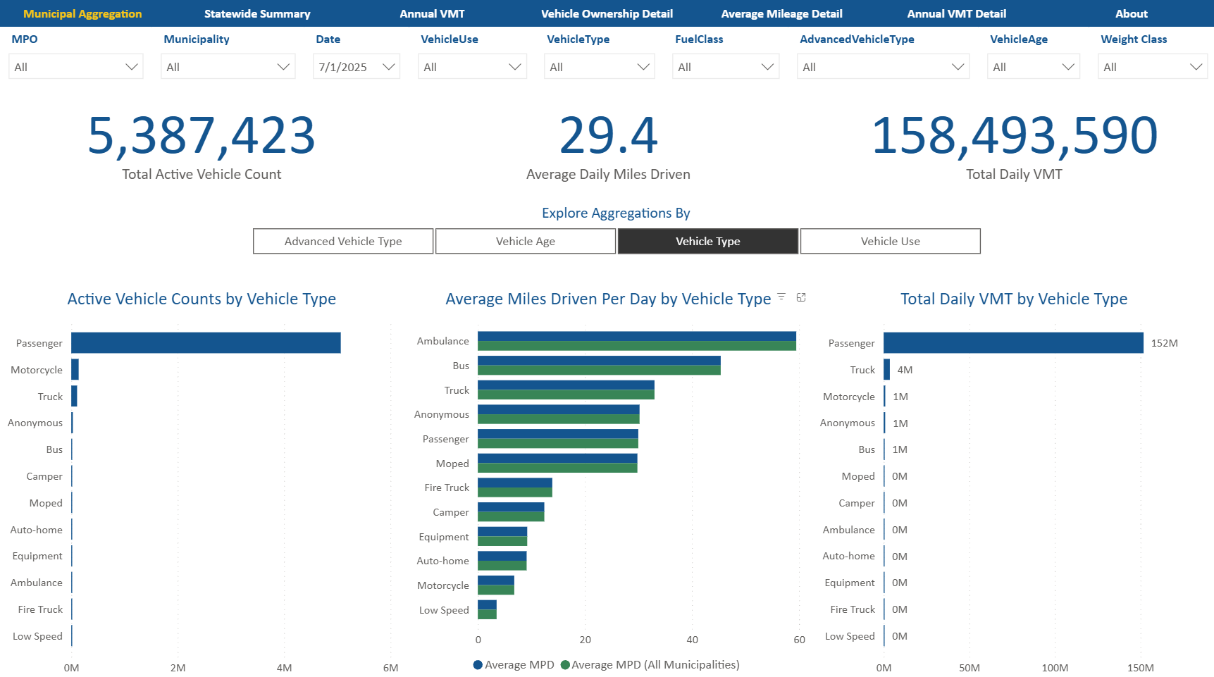
OPMI also created an interactive dashboard that allows users to explore the data. This dashboard allows users to easily analyze MVC data without needing experience in manipulating data. Users can filter by year, municipality, fuel class, vehicle type, and other attributes. Users can view annual summaries, snapshots, and explore all metrics available in the published datasets. The dashboard features an interactive map which allows users to quickly understand spatial trends.
Although this is a technical project, it’s more than that. It is a transformation in the way we understand travel in Massachusetts. The purpose of the MVC is simple: to increase our understanding of travel in Massachusetts while enhancing how Massachusetts residents access data. Whether you are using this data for planning, research, or simply to fulfill a curiosity, the public dashboard makes complex data accessible and simple to understand.
Stay tuned to the Data Blog for more MVC data in the future!